

Secret Lagoon in Iceland Travel Guide
Secret Lagoon in Iceland is located within the Golden Circle travel area near Reykjavík....
Learn More

Get to know Iceland
Iceland’s glaciers are large ice formations that play a central role in shaping the country’s geography. Located along the South Coast, across the central highlands, and along interior edges, glaciers in Iceland range from extensive ice caps to outlet glaciers that descend into valleys, river systems, and coastal plains.
What distinguishes Iceland’s glaciers is their unusually high concentration relative to the country’s size. Iceland has the highest glacier-to-land ratio of any inhabited country, meaning a larger share of its surface is covered by ice than anywhere else where people live. Major systems such as Vatnajökull coexist with smaller glacier tongues shaped by volcanic terrain, and each glacier occupies a defined region that influences hydrology, landform development, and the alignment of main road corridors. Many glaciers terminate in lagoon systems, including Jökulsárlón, where calving ice, meltwater flow, and coastal drainage converge as part of the same glacier network.
Because many glacier fronts and lagoon-connected outlets are reachable from public roads, glacier access in Iceland is closely tied to self-drive travel. Campervan travel provides a practical way to traverse the glacier landscape, linking glacier termini, glacier lagoons, and the limited access points where glacier-based activities are possible, while remaining positioned close to the ice. Activities such as glacier hiking, ice caving, and ice climbing are only possible on specific glacier edges with suitable surface or internal structures, and access to those locations is constrained by seasonality and road conditions that determine whether the glacier margin can be safely reached.
Glacier-focused travel in Iceland typically follows well-defined driving corridors such as the South Coast, the Vatnajökull region, and the Golden Circle, most often organized into 3-, 7-, or 10-day itineraries.
Iceland’s glaciers are large, slow-moving ice formations made up of ice caps and ice fields that cover a substantial part of the island. They extend across volcanic mountain ranges, highland plateaus, and coastal areas, shaping major rivers, valleys, and shorelines. One of the most significant examples is Vatnajökull, which illustrates the scale of Icelandic glaciation while remaining part of a wider system of outlet glaciers and ice tongues connected to the surrounding terrain.
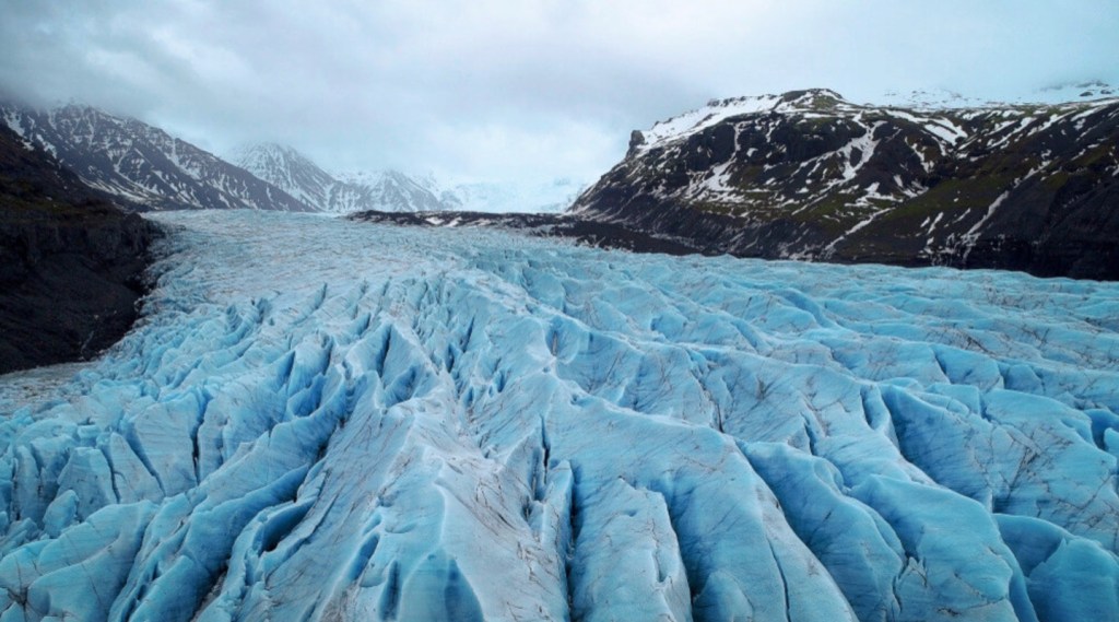
The glaciers are spread across multiple regions, from areas near Reykjavík to the remote southeast, rather than being concentrated in a single zone. Structurally, they consist of layered ice, crevasse fields, exposed blue ice, and melting margins where ice feeds glacial rivers and lagoons. These physical characteristics make many glaciers suitable for guided glacier hikes and organized glacier tours, depending on access and seasonal conditions.
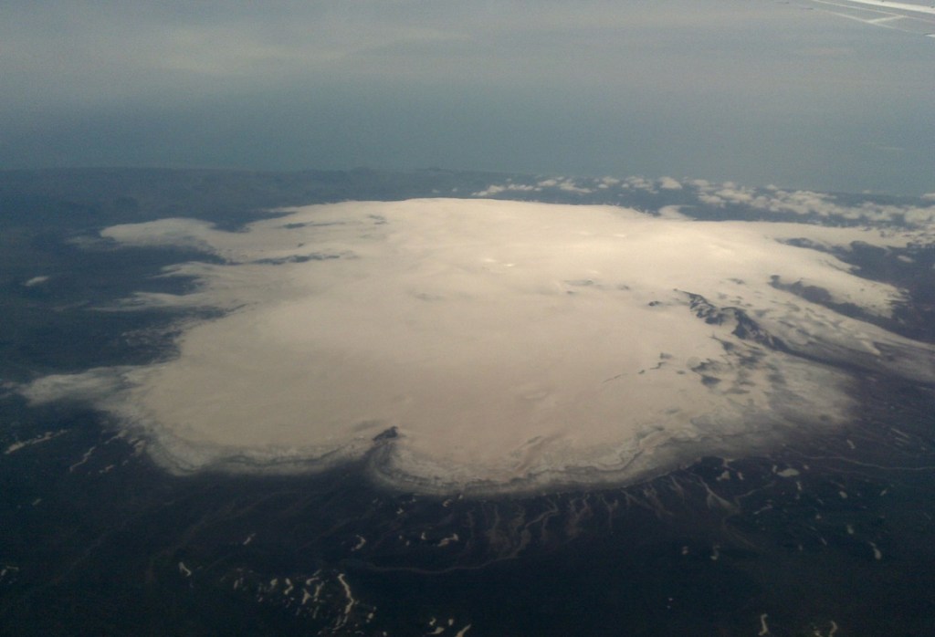
Iceland’s glaciers are large ice formations that dominate the country’s geography and shape much of its physical landscape, covering approximately 11% of Iceland’s land area, or about 11,000 square kilometers. Distributed along the South Coast, across the central highlands, and along interior margins, Icelandic glaciers range from extensive ice caps to outlet glaciers that descend into valleys, river systems, and coastal plains.
What distinguishes Iceland’s glaciers is their density and variation across relatively short distances. Major ice caps such as Vatnajökull coexist with smaller glacier tongues formed over volcanic terrain. Each glacier occupies a defined geographic zone and plays a direct role in hydrology, sediment transport, and landscape formation. Many outlet glaciers terminate in glacier lagoons, such as Jökulsárlón, where ice movement, meltwater, and coastal processes intersect as part of the same glacial system.
Because many glaciers extend close to lowland areas and road networks, access conditions shape how people interact with them. Glaciers that can be reached by road support structured activities such as glacier hiking, ice caving, and guided ice travel, while more remote ice remains inaccessible without specialized routes or equipment.
Campervan travel becomes relevant at this point, as it enables flexible movement between glacier fronts, lagoon termini, and glacier-access zones without relying on fixed accommodation. As a result, glacier-focused travel in Iceland is commonly organized into route-based itineraries (such as South Coast glacier routes, Vatnajökull-centered tours, and Golden Circle extensions), typically structured into 3-, 7-, or 10-day plans. This guide places Iceland’s glaciers within that route-based travel context, focusing on how ice, access, and geography align.
Glaciers in Iceland are primarily divided into ice caps and outlet glaciers, two major types defined by their structure, formation, and relationship with the surrounding landscape.
Ice caps are the largest and most dominant glacier type in Iceland. They consist of thick, continuous ice fields that cover extensive areas of land, mainly in the central highlands. Ice caps form over long periods under maritime climates and rest directly on volcanic terrain, creating elevated ice masses that shape regional geography and drainage systems. The scale of Vatnajökull illustrates how Icelandic glaciers occupy broad interior regions rather than isolated mountain summits.
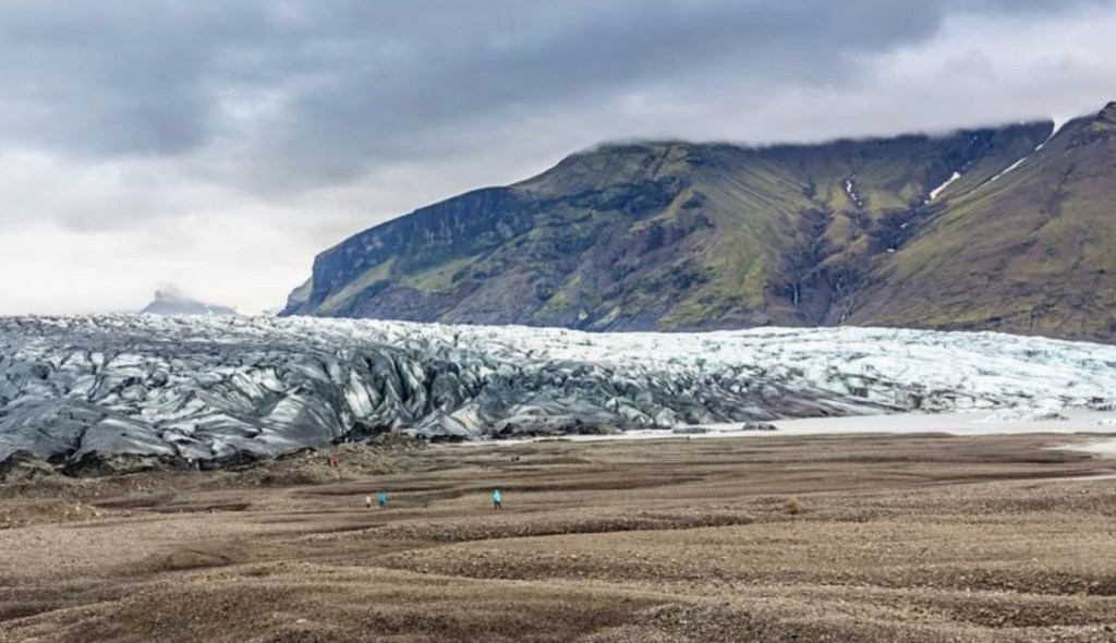
Outlet glaciers extend outward from the edges of ice caps and transport ice downslope into valleys, plains, and coastal areas. Also referred to as glacier tongues, they are shaped by gravity and surface melting as ice flows away from high accumulation zones. Outlet glaciers are narrower than ice caps and far more accessible, which makes them the most visible glacier fronts along major travel corridors such as the South Coast and regions closer to Reykjavík.
Vatnajökull is the largest glacier in Iceland and one of the largest ice caps in Europe. Located in southeast Iceland, it covers approximately 7,900-8,100 km², accounting for nearly 8% of the country’s land area. The ice cap is sustained by heavy maritime snowfall and rests on volcanic terrain. Vatnajökull includes numerous outlet glaciers, such as Skaftafellsjökull and Breiðamerkurjökull.
Langjökull is the second-largest glacier in Iceland and is classified as an ice cap located in the west-central highlands. Covering approximately 900–950 km², it represents a major share of Iceland’s total ice coverage outside the southeastern glacier systems and appears as a key ice mass on national glacier maps.
Langjökull is also one of the glaciers near Reykjavík, situated roughly 120–150 km from the capital, with typical driving times of about 2–2.5 hours under normal conditions. This proximity places it among the large ice caps that are relatively close to Iceland’s primary entry region. Access to Langjökull is season-dependent: while the ice cap itself is permanent, road access to its margins varies with weather, snow accumulation, and seasonal road openings, particularly outside the summer period.
Hofsjökull is one of the three largest glaciers in Iceland, covering approximately 925 km². It is classified as an ice cap and is located in the Central Highlands of Iceland, a region defined by high elevation, sparse infrastructure, and extensive glacial and volcanic terrain.
Hofsjökull is distinctive among Icelandic glaciers because it overlies an active volcanic system, the Hofsjökull central volcano, which is the largest active central volcano in Iceland by area.
Meltwater from the Hofsjökull ice cap feeds several major Icelandic river systems, including the Þjórsá, Blanda, and Héradsvötn.
Mýrdalsjökull is a large ice cap in southern Iceland, covering approximately 590–600 km², which places it among the larger Icelandic glaciers by area. It overlies the Katla volcano, one of Iceland’s most active volcanic systems.
Geothermal heat beneath the ice influences melt patterns, ice structure, and subglacial drainage, while repeated volcanic activity has shaped both the thickness and behavior of the ice cap over time.
Sólheimajökull is an outlet glacier extending from the Mýrdalsjökull ice cap. It flows from higher accumulation zones toward lower terrain in southern Iceland, functioning as a transport channel for ice within the larger glacial system. Located approximately 160 km east of Reykjavík, about 2.5 hours by road via the South Coast, and roughly 25 km west of Vík, Sólheimajökull is one of the most accessible outlet glaciers in Iceland in spatial terms, positioned directly off Route 1 and integrated into the South Coast glacier corridor.
Skaftafellsjökull is an outlet glacier of Vatnajökull that descends through the Skaftafell region in southern Iceland. Originating in the central ice cap mass, it channels ice outward toward lower elevations and represents a typical outlet-glacier structure within Iceland’s largest glacier system.

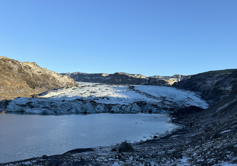
Breiðamerkurjökull is a major outlet glacier of Vatnajökull in southeastern Iceland. The glacier terminates at a calving front where large volumes of ice detach from the glacier margin and enter adjacent meltwater systems. This continuous calving process drives the formation of icebergs and directly links Breiðamerkurjökull to downstream hydrological flow, making it a key example of active ice mass transfer within Iceland’s glacier system.

Jökulsárlón is a glacier lagoon in southeastern Iceland formed by the calving of Breiðamerkurjökull, an outlet glacier of the Vatnajökull system. The lagoon developed as glacier retreat and meltwater accumulation created a basin at the ice margin. Repeated calving events release large ice blocks into the water, where they become icebergs. This process links Jökulsárlón directly to ice movement, fragmentation, and melt dynamics within the Vatnajökull glacier system, making it a structural component of the region’s glacier-lagoon network rather than a standalone body of water.
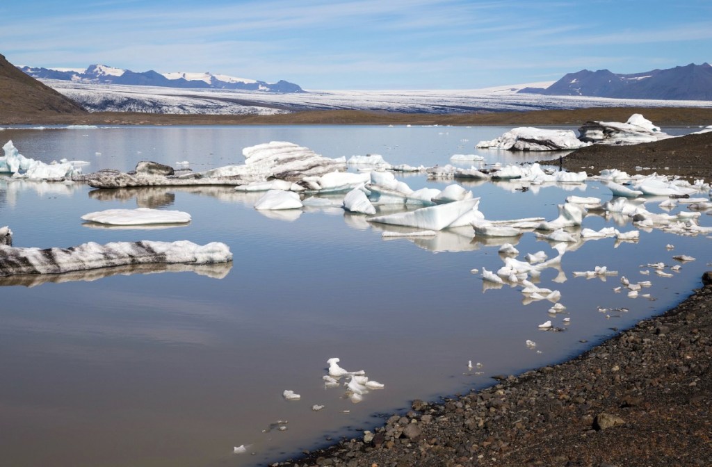
Fjallsárlón is a glacier lagoon in southern Iceland formed by calving from Fjallsjökull, another outlet glacier connected to the Vatnajökull ice cap. The lagoon is sustained by ongoing meltwater flow and ice break-off at the glacier front, with calving events supplying icebergs directly into the lagoon. Fjallsárlón’s size and iceberg presence depend on Fjallsjökull’s behavior, keeping the lagoon structurally tied to glacier dynamics rather than treated as an independent geographic feature.
Glacier hiking is the activity of walking on glacier ice with appropriate equipment under the supervision of a trained glacier guide. Glacier hiking takes place on accessible surfaces of Iceland glaciers, most often on outlet glaciers or glacier edges where ice in Iceland includes crevasses, meltwater channels, and uneven ice fields.
Because glaciers in Iceland move and melt continuously, glacier hiking is usually conducted as guided tours with safety procedures designed around changing cracks, shifting snow cover, and unstable margins. Glacier hiking is common in the Vatnajökull glacier region and on accessible areas linked to the Skaftafell glacier zone, making it a structured way to traverse Icelandic glaciers under controlled conditions.
Ice caving is the exploration of natural ice caves within glaciers. Ice caves form when seasonal melting and internal meltwater flow carve hollow passages through glacier ice, and the cave structure changes as ice in Iceland melts, refreezes, and shifts through glacier movement. Vatnajökull glacier is the best-known region for ice caves because its large ice cap and outlet-glacier system support recurring cave formation across different sectors.
Many ice caves feature blue ice walls and compact, clear ice, formed by low air content, revealing the internal structure of Icelandic glaciers rather than a separate cave environment. Ice caving requires guided glacier tour access for safety and conservation, and conditions are most stable during colder periods, as described in our Iceland in winter guide.
Ice climbing is the activity of ascending vertical or near-vertical glacier ice on Icelandic glaciers using ice axes and crampons. Ice climbing takes place on glacier ice walls, steep crevasse edges, and stable faces where the ice forms climbable angles and holds.
In Iceland, these climbable surfaces often occur on outlet glaciers such as Sólheimajökull and along parts of the Vatnajökull glacier system, where the ice margin creates exposed walls. Ice quality and stability depend on temperature, surface hardness, melt risk, and internal flow, so ice climbing is only permitted with certified glacier guides as part of controlled glacier tour operations.
You get to glaciers in Iceland by self-driving a campervan on established road corridors, using either paved roads, gravel roads, or highland routes, depending on glacier location and seasonal conditions.
Because glaciers in Iceland are distributed across the South Coast, the southeast, and interior edges, campervan travel allows direct movement between glacier viewpoints, glacier tour meeting points, and glacier-adjacent parking areas without returning to Reykjavík each night. This allows following glacier corridors in sequence rather than treating each glacier as a separate trip.
Road conditions are the primary constraint. Many glacier access points lie beyond Route 1 on gravel roads or highland approaches that change quickly with weather, snowmelt, and surface erosion. As a result, 2WD access is sufficient for some glaciers, while 4×4 capability becomes necessary for others, especially near ice caps and inland terrain. Seasonal factors are critical, and guidance on the best time to visit Iceland helps determine which glacier roads are open and drivable at different times of year.
CampEasy campervans support this structure by matching vehicle capability to glacier access tiers outlined below.
Easy Access 2WD refers to glaciers in Iceland that are accessible via paved or well-maintained gravel roads, without F-roads or 4×4 requirements.
This access level fits travelers using standard road corridors from Reykjavík and along Route 1, and it aligns with CampEasy Easy Auto camper use for self-drive glacier routes that stay on main roads. These glaciers are among the most accessible in Iceland and are commonly chosen for first glacier experiences.
These glaciers are well marked on any glacier map and are ideal for self-drive planning in Iceland in summer, when conditions on Route 1 are most stable. This tier establishes the baseline before moving into more remote glacier access.
Moderate 4×4 access applies to glaciers that require a 4×4 vehicle for legal and practical travel on rougher gravel roads or select F-road segments, without involving extreme terrain or river crossings.
This tier expands glacier reach beyond Route 1 while remaining within normal self-drive feasibility for prepared travelers. CampEasy models such as the Easy Clever 4×4 and Easy Viking 4×4 are suited to this category due to their clearance and traction on uneven surfaces.
Seasonal transitions are especially relevant for this tier, and conditions often reflect the reduced daylight, storms, and early snow risks described in Iceland in autumn. This category bridges simple glacier access and full highland travel.
Advanced (Summer Only) 4×4 access refers to glacier areas that require highland F-roads, remote-terrain tolerance, and seasonal road openings, making them accessible only during the summer window.
These routes connect to interior Icelandic glaciers, including remote edges of the Vatnajökull glacier system and ice-cap-adjacent highland plateaus. Access depends on road openings controlled by snowpack, meltwater, and surface stability, and routes remain closed or unsafe outside the summer season.
CampEasy high-capability models such as the Easy Monster 4×4, Easy Luxury 4×4, and Easy Viking 4×4 are required here because clearance, traction, and stability are essential for glacier proximity rather than optional comfort. Route planning in this tier is map-driven and must include road-status checks and awareness of distance to services.
The most reliable access window aligns with mid-summer conditions, and Iceland in July is a common reference point for when highland routes are most likely to be open. This tier defines the outer limit of glacier accessibility by campervan, focusing on access to remote glacier zones rather than glacier activities.
The 3-day glacier route is a compact, campervan-friendly South Coast loop that begins and ends in Keflavík, connecting South Coast glaciers, Vatnajökull glacier, and key glacier lagoons in the shortest practical timeframe. The route follows a clear structure: Keflavík → South Coast glacier corridor → Vatnajökull edge and lagoon zone → return to Keflavík, so glaciers in Iceland are covered as a coherent system rather than as isolated stops.
CampEasy campervans suited to this short glacier itinerary include the Easy Auto for standard Ring Road driving and the Easy Clever 4×4 for added flexibility on mixed gravel segments, without shifting the route into highland-only terrain. Trip context and pacing align well with the longer planning framework in our Iceland campervan trip guide.
Day 1 route begins in Keflavík and travels toward the South Coast glaciers corridor, as this region contains the most road-accessible Icelandic glaciers within a short driving distance from the airport area. The segment typically covers ~230–280 km depending on the overnight endpoint, with an estimated driving time of ~3–4 hours on Route 1 excluding stops.
Sólheimajökull appears as the primary glacier-facing stop along this leg, while Mýrdalsjökull functions as the larger ice cap reference in the same South Coast system. Day 1 commonly ends near the glacier zone with campsite positioning around the Vík area or comparable South Coast camping nodes, keeping the itinerary aligned for the eastward shift toward glacier lagoons on Day 2.
Day 2 route continues east from the South Coast glacier zone. It connects glacier tongues to lagoon systems along the Vatnajökull margin, forming the core transition from ice-front access to meltwater dynamics. The segment generally covers ~150–200 km with an estimated driving time of ~3–4 hours without extended stops, following Route 1 through the Vatnajökull region.
Skaftafellsjökull anchors the glacier-front portion of the day, followed by the lagoon-linked outlet system of Breiðamerkurjökull, where Jökulsárlón and Fjallsárlón sit as the primary glacier lagoon endpoints. Overnight logistics typically place camping near the Jökulsárlón area or along Vatnajökull’s edge so that the final return day can begin from a clearly defined southeast endpoint.
Day 3 route returns from the glacier lagoon region near Vatnajökull to Keflavík by following Route 1 / Ring Road, completing the 3-day glacier loop as a direct westbound travel leg. The drive usually totals ~370–400 km and takes ~5–6 hours without long stops, making distance and timing the primary planning variables on this day.
The return corridor passes the familiar South Coast segment, where short, optional stop windows can align with locations like Vík, Seljalandsfoss, or Skógafoss without changing the route’s core purpose as a return leg. The day ends with CampEasy drop-off near Keflavík, reinforcing the contrast between this short glacier itinerary and the broader pacing of 7- or 10-day glacier routes.
7-Day Glacier Route is a one-week glacier route that follows a Ring Road circuit from Keflavík and returns to Keflavík, extending glacier coverage beyond the 3-day loop with more time in the Vatnajökull region, glacier lagoons, and selected Highlands edge terrain. The itinerary keeps a clear progression: South Coast glaciers → Vatnajökull glacierand Skaftafell glacier hub → east-side glacier tongues → Highlands edge → westward return, so Iceland glaciers are explored as connected zones rather than rushed stops. Glacier hike and glacier tour options in Iceland fit more naturally into this timing because lagoon visits and glacier-front days are spaced out with lower-mileage buffers.
CampEasy 4×4 models such as the Easy Clever 4×4 and Easy Viking 4×4 suit the route’s mixed road profile, and planning commonly begins from a central campervan rental in Iceland base near Keflavík, before the loop starts.
Day 1 departs Keflavík and follows the Ring Road southeast into the South Coast, ending in Vík as the first overnight base. The segment covers about 220 km and takes roughly 3 hours of driving time without extended stops, positioning the route directly within the South Coast glacier corridor.
Mýrdalsjökull becomes visible along this stretch, establishing early glacier proximity without requiring multiple stops. Vík serves as an overnight base because it sits close to southern outlet glaciers and provides efficient access to Sólheimajökull and travel to Vatnajökull on Day 2. Campsites in and around Vík provide a practical reset point for campervan pacing.
Day 2 continues east from Vík to Skaftafell along Route 1, shifting from coastal staging into the first full glacier hub day tied to Vatnajökull systems. The drive is about 140 km and takes 2–2.5 hours, allowing early glacier-side stops. Sólheimajökull appears as a logical early stop, while Mýrdalsjökull remains visible before the route reaches the broader Vatnajökull ice fields.
Skaftafell concludes the day as a base because the Skaftafell area functions as a structured access point for glacier hiking and glacier tours connected to Vatnajökull outlets. The campsite supports overnight staging directly beside the glacier edge.
Day 3 centers on southeast glacier hydrology with minimal driving and extended on-site time. The short drive from Skaftafell to Fjallsárlón and onward to Jökulsárlón is about 55 km and takes under an hour. Fjallsárlón offers close-up glacier-front views, followed by Jökulsárlón, where icebergs originate from the Breiðamerkurjökull outlet.
Optional short walks and lagoon-side viewpoints keep the focus on ice movement and meltwater dynamics. Overnight positioning can remain near the lagoon area or return to Skaftafell, depending on preferred pacing for the next day.
Day 4 moves away from the lagoon cluster and explores the quieter east-facing margins of the Vatnajökull system by continuing northeast on Route 1. The segment typically covers 110–130 km and takes 1.5–2.5 hours to drive, emphasizing slow exploration. Optional detours to Heinabergsjökull or Hoffellsjökull introduce less-visited outlet glaciers with short approaches from the road. Höfn or Djúpivogur serves as a practical overnight zone, balancing access to east-side glacier tongues with essential services.
Day 5 shifts the route toward the highland edge, where glacier-fed valleys and elevation changes create a different access profile from the Ring Road. Driving distance usually falls between 120–160 km, with 2.5–4 hours of driving depending on the selected approach. Areas such as Lónsöræfi and the Öræfi region mark the transition to rougher gravel surfaces.
Seasonal F-roads may be possible only when conditions allow, making 4×4 capability essential. CampEasy high-clearance models align with this day’s access needs. Overnight plans depend on weather and road status, with options near the highland edge or a retreat to paved-road campgrounds.
Day 6 follows the Ring Road west, repositioning the route from the highland edge back toward more accessible South Coast infrastructure. The drive typically spans 200–240 km, takes 3.5–5 hours, and serves as a transition day. Glacier visibility continues along the route through distant Vatnajökull outlets. Kirkjubæjarklaustur is a common overnight stop, keeping the final day manageable, with Vík as an alternative if the return pace is faster.
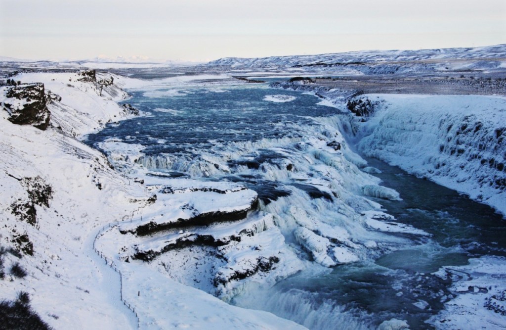
Day 7 completes the loop via the Golden Circle before returning to Keflavík. The day usually covers about 300 km with 4.5–5.5 hours of driving time. Gullfoss anchors the glacier connection through meltwater sourced from the Langjökullsystem, keeping ice in Iceland relevant even away from glacier fronts. Geysir and Þingvellir add geothermal and tectonic context before the route returns to the CampEasy drop-off near Keflavík Airport, closing the 7-day glacier circuit with clear timing and logistics.
The 10-day glacier route is an extended campervan glacier circuit that starts and ends in Keflavík and connects Iceland’s major glacier regions into a single continuous loop. This route expands glacier coverage beyond the South Coast to include the Vatnajökull glacier system, the East Fjords, interior Highlands terrain, Langjökull, West Iceland, and the Westfjords. The itinerary unfolds as a structured glacier arc: Days 1–3 establish the South Coast and Vatnajökull approach, Day 4 deepens exposure inside the Vatnajökull region, Day 5 traces glacier-shaped East Fjords coastlines, Day 6 enters the Highlands with 4×4-only access, Day 7 adds a Langjökull extension, and Days 8–10 complete the western and northwestern return before closing back at Keflavík. Because the route combines Ring Road driving with interior F-roads and highland tracks, CampEasy 4×4 campervans must maintain route continuity without detours.
Days 1–3 anchor the 10-day glacier route by following the same structural foundation as the shorter South Coast loop, running from Keflavík through the South Coast glaciers to the Vatnajökull region and glacier lagoons. This segment establishes the southern glacier corridor in sequence: Keflavík entry, South Coast glacier frontage with visibility of Sólheimajökull and Mýrdalsjökull, Skaftafell glacier positioning, and glacier lagoons linked to Breiðamerkurjökull. These days introduce Iceland’s most accessible, high-density glacier geography while keeping daily driving moderate to support the longer route ahead.
Day 4 shifts the itinerary from glacier-edge stops into deeper Vatnajökull glacier territory within Vatnajökull National Park. The focus moves from roadside glacier frontage to controlled interior access, where viewpoints, short hikes, and limited off-main-road approaches provide a stronger ice-cap context. This day marks the transition from observing glacier margins to engaging with the scale and structure of Iceland’s largest ice cap. CampEasy 4×4 capability becomes essential here, as road choices and surface conditions determine how far into the glacier interior the route can be responsibly extended.
Day 5 transitions the route from southeast Iceland into the East Fjords, where glacial erosion and meltwater systems shape fjords, valleys, and coastal inlets. Direct glacier-front stops become less frequent, but the glacier influence remains visible through carved landscapes and river systems. This day functions as a glacier-legacy segment, maintaining the glacier theme while providing a lower-intensity driving and exploration rhythm between major ice-cap zones. Standard roads dominate, with optional gravel spurs accessible by 4×4 for elevated viewpoints.
Day 6 introduces a highland detour, changing the route’s access logic from coastal highways to Icelandic highland roads. F-road classifications, volcanic plains, glacial outwash zones, and weather exposure define this segment. CampEasy 4×4 campervans are mandatory, as traction, clearance, and stability govern safe travel more than distance. Glacier visibility varies by route, but the purpose of this day is consistent: reaching remote volcanic–glacial terrain that links Iceland’s interior landscapes to the wider glacier circuit before the route turns west.
Day 7 positions the route in west-central Iceland and adds Langjökull as the western glacier anchor of the itinerary. Access typically follows corridors near Húsafell or interior gravel routes, where mixed surfaces make 4×4 capability essential. Langjökull differs from earlier glacier stops by emphasizing interior glacier features and structured access experiences rather than lagoon or outlet-front systems. This day marks the end of the interior glacier phase before the route transitions into West Iceland and the northwest.
Day 8 shifts focus from concentrated glacier travel to West Iceland’s waterfalls, geothermal areas, and cultural sites while maintaining overall route momentum. Hraunfossar, Deildartunguhver, and Reykholt are commonly used to structure the day, with an optional Snæfellsnes detour treated as a flexible extension rather than a core requirement. CampEasy campervan flexibility allows pacing adjustments without affecting the timing needed to reach the Westfjords and complete the circuit.
Day 9 extends the route into the Westfjords, the most remote section of the 10-day glacier circuit. Long fjords, winding coastal roads, and limited infrastructure slow the pace and reinforce the end-to-end nature of the itinerary. Dynjandi waterfall and Ísafjörður commonly anchor the day, with Látrabjarg cliffs remaining optional depending on conditions. This region also supports wildlife-focused planning, including dedicated resources for watching puffins in Iceland, which can be integrated without shifting the route away from its glacier-driven structure.
Day 10 completes the glacier circuit by returning from the Westfjords or West Iceland to Keflavík International Airport. This final leg often requires a long driving window, with Borgarnes or the Reykjavík outskirts serving as practical rest and fuel buffers. CampEasy campervan drop-off near the airport closes the loop cleanly, reinforcing the route as a whole glacier arc (from South Coast ice to eastern fjords, highland interiors, western glaciers at Langjökull, and the northwest), returning to Keflavík for departure.


CampEasy Opening hours 09:00-16:00
Learn more about Self-Service
A minimum of 20 hours notice is required to use the booking engine. Click here to contact us directly for a booking less than 20 hours from now.
Change Date